Best Apps to Track Your Kilimanjaro Hike
Turn Your Phone Into a Summit-Tracking Tool
Climbing Mount Kilimanjaro is more than just a physical challenge,it’s a journey worth recording. Whether you’re keeping track of your altitude, steps, or route, the right hiking apps can enhance your experience and help you track your Kilimanjaro hike like a pro.
At Mandari Travel, we’ve guided hundreds of climbers to the summit, and many ask us: What are the best apps to use on Kilimanjaro? In this guide, we share our top picks for GPS tracking, offline maps, health monitoring, and more.
Top 5 Apps for Tracking Your Kilimanjaro Trek
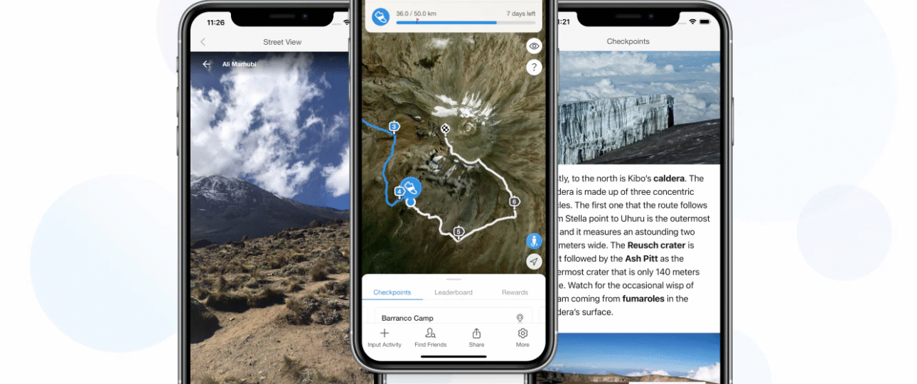
1. AllTrails
Best for: Route planning and offline maps
Why we like it: AllTrails has accurate GPS maps for popular Kilimanjaro routes like Machame, Lemosho, and Marangu. Download your trail offline and use GPS to track your position,even with no signal.
Free version available
Battery-friendly with offline mode
2. Gaia GPS
Best for: Advanced GPS navigation
Why we like it: Gaia is a favorite among serious hikers for its detailed topographic maps, elevation profiles, and offline tracking. Ideal if you want to monitor your climb’s progress precisely.
Tip: Download maps before your trek,Kilimanjaro has limited reception.
3. Altitude by PixelProse (Android) / My Altitude (iOS)
Best for: Real-time altitude and barometric pressure
Why we like it: Altitude matters on Kilimanjaro. These apps show your current elevation, pressure, and GPS coordinates, handy for understanding how your body is adapting.
No data required
Works in airplane mode
4. Strava
Best for: Tracking steps, pace, and sharing your progress
Why we like it: Use Strava to track distance, elevation gain, and heart rate if you’re using a smartwatch. It also lets you share your journey with friends and followers when you reconnect.
Syncs with Garmin, Apple Watch, Fitbit
Great for post-hike memories
5. PeakFinder
Best for: Identifying surrounding peaks
Why we like it: From Uhuru Peak, you’ll see incredible landscapes. Use PeakFinder to identify mountains and volcanoes in the distance. It works offline and adds a fun twist to your summit views.
Augmented reality included
Beautiful mountain visuals
Pro Tips for Using Apps on Kilimanjaro
- 🔋 Bring a power bank or solar charger—cold temperatures drain batteries fast
- 📴 Use airplane mode + GPS to save energy
- 📲 Download all maps and routes before your trek
- 🌍 Don’t rely solely on phones—our Mandari Travel guides always carry physical maps and safety gear
Climb Smarter with Mandari Travel
Planning your Kilimanjaro adventure? We provide expert guides, full support, and personalized trek planning, including advice on gear, apps, and acclimatization.
Email: info@mandaritravel.com
📞 Call/WhatsApp: +255 750 900 811
Or fill out the form below to request a Kilimanjaro climbing quote: